|
||||
| Site Quicklinks | ||||
 Search Contact Information John Bolte 116 Gilmore Hall  |
Download Envision Datasets for the Eugene Study Area IDU coverage (1GB)and the Eugene Study Area Inputs (55MB) Draft Scenario Results are available here
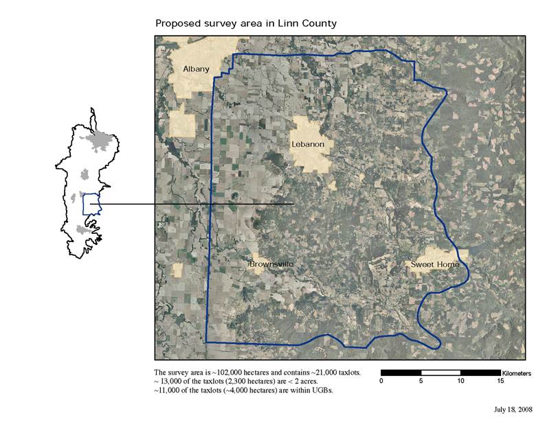
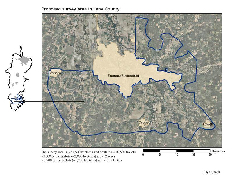
We employ an approach that downscales from the coarse scales Dynamic Global Vegetation Models to the fine scales at which human land use and management decisions are made, and then scales back up to represent the landscape-scale effects of human actions on vegetation and fire hazard. Through the use of an agent-based model, individual decision makers respond to a suite of factors including climate, land use regulation and incentives, land markets, fire hazard, land management costs and aesthetics. Agent behaviors are parameterized probabilistically based on a survey of study area landowners as well as census and other local data. We test three hypotheses: 1) climate change will lead to altered fuel loads and greater wildfire hazard at fine spatial extents in the WVE; 2) current WVE land use trajectories will lead to increased wildland-urban interface area and changes in vegetation that together increase the risk of wildfire and loss of imperiled ecosystems; and 3) some policy sets will be more robust than others in reducing fire risk and sustaining imperiled ecosystems across a range of future climate scenarios. Study Areas: We are examining two study areas, in Linn and Lane Counties, Oregon
Collaborators include: Bart R. Johnson (1), Robert G. Ribe (1), David W. Hulse (1), John P. Bolte (2), Scott D. Bridgham(1), Gabriel I. Yospin (1), Timothy Sheehan (1), Max Nielson-Pincus (1), Alan A. Ager (3), Jane A. Kertis (4), Dominique Bachelet (2), Ronald P. Neilson (4), David Conklin (2), Constance A. Harrington (5) and Peter J. Gould (5). (1) University of Oregon, Eugene, OR, (2) Oregon State University, Corvallis, OR, (3) USDA Forest Service, Prineville, OR, (4) USDA Forest Service, Corvallis, OR, (5) USDA Forest Service, Olympia WA |
|||
 This page describes an effort using Envision to assess the future effects of climate change on coupled natural/human systems in two study areas in the Willamette Valley. Our goal is to identify policies that reduce fire hazard and the loss of imperiled ecosystems by exploring the coupled effects of climatic and human-induced landscape changes on wildfire hazard and biodiversity. Working in western Oregon’s rapidly changing Willamette Valley Ecoregion (WVE), we are investigating human/natural systems by linking models of how climate change affects forest succession and wildfire in historic grassland/savanna ecosystems with Envision. We contrast conventional predict-then-act approaches with our explore-then-test approach in which we build a transferable analysis platform that allows us to: a) explore large numbers of alternative future landscapes; b) seek robust rather than optimal alternatives for reducing risk of wildfire and biodiversity loss given the deep uncertainties of local manifestations of future climate change; and c) identify land management policies that facilitate such robustness.